

After the storm
Violent winds cause havoc in Hallettsville
Mother nature unleashed her fury Friday night, Feb. 2 as tornadic type winds passed through the Hallettsville area leaving a number of trees and limbs downed on county roads as well as storage buildings destroyed during the storm.
As Friday started, weather forecasters predicted the chance of violent storms passing through Lavaca and surrounding counties and as evening fell the frontal storm developed.
Between 11 to 11:30 p.m. Friday night the storm hit the Hallettsville area packing winds gusting up to a reported 65 miles an hour or higher.
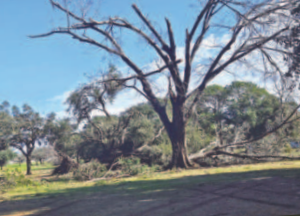
In its wake, a ton of damage took place including a large number of trees and limbs downed at the Hallettsville City Park.
The Youth Soccer goals at its field in the park were twisted and mangled as well as an oak tree in a Hallettsville Golf Course fairway stripped of its limbs.
At the Hallettsville baseball field, the wind lifted a metal covering throwing it into the backstop and ripping a huge hole in the netting.
The winds appeared to follow a path to the east of Hallettsville where downed trees along with sheds and barns suffered damage.
At the Leon “Bubba” and Sheryl Barnes place located on FM 2314, their storage barn had a large amount of damage.
A little further to the east at the Irene Gummult home on CR 138, although her home was not damaged, two storage buildings behind her home were destroyed leaving tin strewn across fields on the property
On CR 142 near Sublime and the Navidad River, a number of Pecan trees were downed as well with some lying across the county road.
West of Hallettsville on CR 287, a large implement shed belonging to Ronald Henke was completely lifted out of the ground and thrown to an upside down position.
In regards to rainfall, most areas received around two inches, but county and city work crews, and individuals were left with a tedious job of cleaning up.
LCEMHS Storm Report
We reached out to Lavaca County Emergency Management/Homeland Security coordinator Greg Murrile who said the National Weather Service did not think the winds were a result of a tornado, but classified them as micro-burst straight line winds, which could have winds similar to a weak, small tornado.
According to the NWS report and observation of damage, they felt the open air buildings that were damaged were older farm buildings with metal roofs nailed down with no foundation.
The report said the metal roofs can be easily peeled off with winds up to 50 miles-per-hour.
The NWS said they did not notice any substantial damage to any “well built” structures with the closest thing being a few shingles removed from the roof.
In regards to downed trees and limbs, the NWS reported a lot of dead limbs were blown off the trees and due to the very wet ground it made it very easy for the uprooting of trees.
Murrile reported on the reason Code Red Alerts were not issued the night of the storm.
“Code Red Alerts for severe weather are issued automatically by the NWS,” Murrile said. “Anytime a Severe Weather ‘Warning’ is issued for a particular area, a Code Red notification is automatically electronically generated for the affected area.
In regards to those who have not subscribed to Code Red, Murrile said your cellular phone has a built in Wireless Emergency Alert System, just like Amber Alerts, which also generate a message to your phone warning you of severe weather in the area. he said this works even when traveling outside your home area anywhere in the United States.
“On Friday night, Lavaca County nor any municipalities were ever put under a ‘severe weather warning’,” Murrile said. “The only thing issued for the area was a ‘special weather statement’ at 10:13 p.m. and a ‘flood advisory’ at 10:34 p.m.”